
Hey, Dr. Zoomie! I’ve got a bit of contamination I’m working with and my regulators are telling me I need to characterize the area before I start cleaning up and again when I think I’m done. I know they mean when they say “characterize” but I’m not quite sure what goes into a characterization plan. Can you shed some light? And what about the remediation – any tips on putting together a remediation plan and doing the cleanup?
OK – so let me start with a few caveats. First is that I can’t answer your question in a single post – there’s just too much to discuss. Second is that even with that having been said, there’s way too much for me to give anything other than an overview of two very complex documents (the characterization and remediation plans) and processes. What I’ll discuss here is a high-level view of what goes into these two topics, but whether you do it yourself or (what I’d recommend) hire a consultant to help you out, there is far more that will need to be done than what I can put in a few blog posts. There have been books written about this. With that, let’s get started!
Characterization (to me, anyhow) is sort of like cleaning the bathroom – not a lot of fun, but when it’s got to be done, it’s got to be done, and it needs to be done correctly. And if you’ve got contamination that’s bad enough to warrant notifying your regulators and doing a cleanup then you’re going to need to do some characterization, whether it’s a room, a building, or a plot of land. And let me add, you really want to do a good job on the characterization. I’ve been involved in four D&D (decontamination and decommissioning) projects that began with a slipshod characterization (three of them performed by the same organization, I’d like to note). The best of these required us to re-do the earlier surveys; of the others, one went badly over budget, one was so bad that the building was never actually remediated owing to the uncertainty the competing characterizations raised, and the other required a lot of on-the-fly adjustments that added both time and cost to the work. And – yes – these all took place more than 20 years ago and they are still seared in my memory. Spending the extra time and money to do a good characterization is one of the best things you can do to get the cleanup off to a good start.
The reason you need to characterize the site is to understand exactly how bad the contamination is, where it’s at, how far it might have spread, and to give yourself a baseline for comparison when you think that you’re finished with the cleanup. In addition, if you include areas that are not contaminated as part of your characterization then you’ll know the background radiation levels and radionuclide concentrations are –cleanup levels are usually in relation to natural levels so the only way we can know when to stop cleaning up is to know the background levels.
So that’s why you need to characterize your site – let’s talk about how to do it. And we’ll start with MARSSIM (the Multi-Agency Radiation Survey and Site Investigation Manual), which came about as a collaboration between the Nuclear Regulatory Commission (NRC), Environmental Protection Agency (EPA), Department of Defense (DOD), and Department of Energy (DOE). The MARSSIM Manual gets into a lot of calculations that I’m not going to discuss here (you’re welcome!) but that you and/or your consultant will need to go through. But these calculations are necessary – they’re how you know that you’re surveying and sampling enough locations to adequately characterize your site and, best of all, they’re objective – if you follow the MARSSIM methodology, including calculations, neither you nor your regulator can be accused of doing a slipshod job, and your characterization plan and subsequent characterization are much less likely to be challenged. If you’re trying to wade through MARSSIM on your own, you might want to check some online tools that can help you out. And what it’s going to come down to is performing a surface survey for radiation levels as well as (maybe) collecting soil samples for analysis.
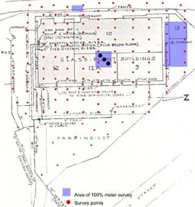
As one example – for one consulting project I recommended surveying the entire site (about 3 acres) on a ten-meter grid (meaning I marked out a grid with lines and rows that were 10 meters apart and took radiation measurements at the intersection of each of these lines). But since we also knew the footprint of the building and, especially, the location of the loading docks, septic tanks, and other locations more likely to show contamination, we recommended surveying these locations on a 1-m grid or via a walkover survey. And, using the results of the radiation surveys, we’d then calculate the number of soil samples we needed to take and send for analysis to meet MARSSIM recommendations. The regulators reviewed the survey and sample plans (which, combined, were the characterization plan) and recommended only a few minor changes – this gave us an official imprimatur and we were good to go.
And I guess I sort of skipped over what the characterization plan actually contained. There was a section on the history of the site and why it needed to be cleaned up, of course. And then it went into how we planned to survey the site – the radiation surveys, the soil samples, and so forth that would be used to determine where remediation needed to be performed, and supporting the survey and sampling plans. And this is where some of the math came in.
What a lot of it comes down to is looking at how variable the survey data was – the more it varies from survey location to survey location, the more samples will need to be taken. And, thinking about it, this makes sense. If I survey, say, a football field and every survey location has exactly the same reading then I can make a strong case that the entire football field has exactly the same levels of contamination. If this is the case, then any single sample from anywhere on that acre of land will give the same reading as any other sample location, which means that a single sample ought to tell us how much contamination is at any spot on the field. On the other hand, if every survey location gives a different reading, varying by, say, a factor of 10 from lowest to highest reading, then it’s going to take a lot more samples to give us a good idea of what’s happening on the site and the places that need to be cleaned up. This is another part of the characterization plan – explaining how you’ll use the radiation survey readings to develop the soil sampling plan. The bottom line is that, by conducting a methodical and disciplined survey plan you can collect the data needed to develop a sampling plan that may not be unassailable, but it’ll be one that you can defend when you present it to your regulators, and that they’re likely to approve.
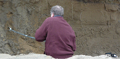
Once you finish the survey and develop your sampling plan you can go ahead and start collecting soil samples, although I’d suggest running it by your regulators first to give them a chance to weigh in. And then – start sampling! Most of the sites I characterized were relatively small and I used a hand auger to collect samples; on a larger site…I’d probably have still used a hand auger, preferrably in the hands of an assistant because collecting samples can get to be sort of tiring.
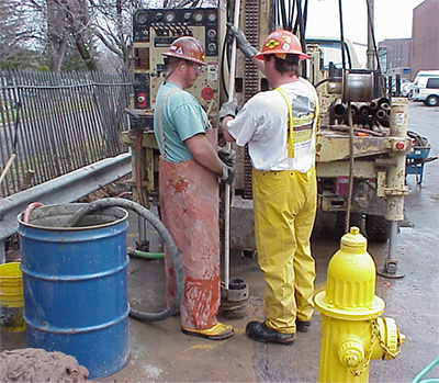
Once you collect the samples you’ll need to send them off to a lab for analysis (which means you’ll need to find a lab, ask for a quotation for analytical costs, and have them ship their sample containers, and cooler to you for shipping the samples back to them to be analyzed) as well as their collection procedure and chain of custody forms. And, when the results come in, you’ll need to decide what they mean – which areas need to be remediated, which areas are OK, and which areas might require further sampling. The bottom line is that your sampling, combined with your radiation surveys, will go into writing up your characterization report, which will be used to develop (and submit) your remediation plan.
And then – submit your characterization report and remediation plan to your regulators for approval, clean up the site, and survey some more to show (one can hope) that the cleanup is completed! And, of course, submit the inevitable report to your regulators for review and approval so you can close out the work and have the site (or room) released for unrestricted use. The fun never ends!